
Chris Rowland: HMS Royal Oak
Artist(s):
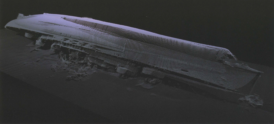
Title:
- HMS Royal Oak
Exhibition:
Creation Year:
- 2007
Medium:
- 3D visualisation of multi-beam sonar point-cloud data
Size:
- Size: 24 inches x 36 inches x 2 inches
Category:
Artist Statement:
The wreck of the HMS Royal Oak lies on the sea bed in Scapa Flow, Orkney. This image was produced from 3D point-cloud data gathered using high-resolution multi-beam sonar during a survey of the wreck in 2006 by ADUS. Historic shipwrecks on the sea bed are of significant interest for a number of reasons. They may contain toxic or explosive cargo or may leak corrosive substances that can adversely affect the local marine environment. However, due to the fact that many of these shipwrecks around the world are not visible to the general public, their environmental and historic significance is often ignored. My work attempts to raise awareness of their potential impact on the environment as well as their place in history, often as tragic memorials to loss of human life, by representing them as monuments, often serenely beautiful, as the sea slowly deconstructs them. This image is intended to be reproduced as a limited-edition, commemorative print to raise funds for the Royal Oak Survivors’ Association and the Royal British Legion, organisations that provide support for exservicemen in the UK. The multi-beam survey by ADUS was commissioned by the Ministry of Defence (UK) Marine Salvage department, which is managing extraction of oil and munitions from the wreck. The 3D visualisation is a result
of my research at the School of Media Arts and Imaging at the University of Dundee, Scotland. The ADUS team consists of: Chris Rowland, Martin Dean, and Mark Lawrence
Technical Information:
The Reson multi-beam sonar system builds a three-dimensional model of the wreck and the sea floor by collecting many millions of accurately positioned “spot heights” derived from the sonar “pings” sent and returned to the sonar head as the survey boat travels back and forth over the wreck. The millions of XYZ points generated from the survey are edited to filter out digital noise, and the resulting dataset is
imported into animation software. The next step is to align the separate lines of data to piece together a 3D image of the complete shipwreck. Each pass can reveal additional
details that add to the overall picture. Our method operates to an accuracy of approximately one centimeter, ensuring that any problem of alignment is minimised. The final step is to use a proprietary plug-in for Maya to apply colour and the illusion of light to the point cloud (imported as particles) and apply principles of digital cinematography to produce the final image.